Mountain Shelves: Courchevel Inclines
In commercial aviation, the word "altiport" refers to a subcategory of airfields engineered into steep mountain terrain with severe runway gradients. They are characterized by a total absence of instrument approach aids and a commitment threshold past which an aborted approach guarantees controlled flight into terrain.
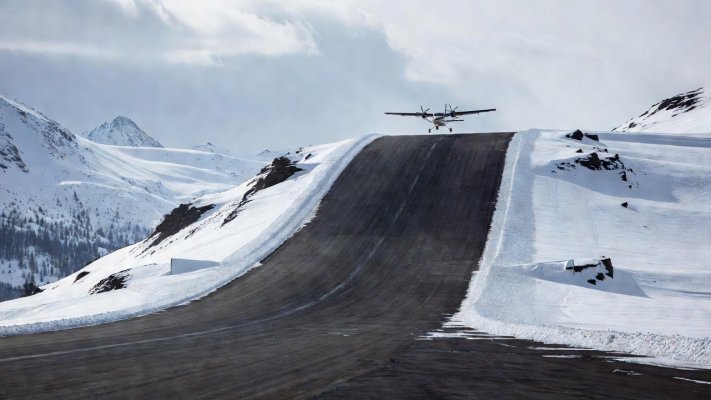
The Geometry of Upward Inclines
Courchevel Altiport (LFLJ), nestled at an elevation of 2,008 meters (6,588 ft) in the French Alps, features an asphalt strip merely 537 meters (1,762 ft) in length. Under standard conditions, a transport aircraft like a de Havilland Canada DHC-6 Twin Otter requires approximately 700 meters to halt safely with dry brakes. Courchevel solves this deficit not with concrete extension, but with gravity.
The runway features a maximum gradient of 18.6%, creating an aggressive ski-jump profile. As the aircraft touches down on Runway 04, the upward hill naturally dissipates kinetic energy. The gradient provides deceleration forces equivalent to heavy reverse thrust, bringing multi-engine turboprops to a walking taxi speed before they reach the summit parking apron.
The Irreversible Departure Dynamic
Departures occur exclusively downhill on Runway 22. Aircraft line up at the high apron and release brakes without run-up thrust, accelerating down the 18.6% slope. Gravity provides instant velocity, allowing aircraft to attain takeoff safety speed (V2) well before the pavement terminates over a sheer 2,000-foot drop into the valley.
This operational symmetry means wind direction is secondary. Aircraft land uphill regardless of tailwinds up to 10 knots, and take off downhill regardless of headwind penalties. The slope dominates every aerodynamic calculation.
Courchevel Flight Profile Metrics
- Runway Designation: RWY 04 (Arrival) / RWY 22 (Departure)
- Threshold Elevation: 6,588 ft (2,008 m) MSL
- Calculated True Airspeed Flare Drift: +14.2%
- Go-Around Point of No Return: Visual Fix "Bellecôte"
Lukla: The Himalayan Precipice
Further east in the Khumbu region of Nepal, Tenzing-Hillary Airport (VNLK) at Lukla shares a similar philosophy under more harrowing conditions. Situated at 2,845 meters (9,334 ft), Lukla’s runway measures 527 meters on an 11.7% gradient.
Unlike Courchevel, which crests into a flat apron, Lukla’s Runway 06 terminates directly against a vertical granite mountain wall. A missed approach cannot be executed once past the Dudh Kosi river gorge. If an aircraft experiences an engine failure below 500 feet Above Ground Level (AGL), standard single-engine climb gradients cannot out-climb the rising mountain walls enclosing the valley.
Specific Mountain Pilot Endorsements
Operating into altiports requires specialized credentials governed by the French Direction Générale de l'Aviation Civile (DGAC) and international authorities. The Qualification Montagne demands ground school on mountain wave rotors, density altitude calculations, and at least five verified approaches under the supervision of a licensed altiport flight instructor.
Currency expires if a pilot does not log a landing at the specific altiport within six months. Failure to maintain currency requires a revalidation check flight, ensuring that pilots who cross these thresholds have recent muscle memory for the rapid visual adjustments required.
Ready to Explore Sea Level Challenges?
From towering granite peaks, explore how civil engineers solve space deficits over deep marine waters using reinforced concrete trestles.
View Marine Trestle Analysis